Five Days in Wyoming - as good as it gets!
I first prepared this route for some friends from back east who had never been out west. Because they seemed to enjoy it, I am putting it up here. You can start it from any point, of course. Being in Sturgis is fun, but not necessary. It is shown as a five-day loop starting near Sturgis and winding up back there - the map shows that route in yellow. You'll note that there are three "breakout" points in the loop, places you can cut away from the route to head off somewhere else you need to be - they are marked with brown, green, and blue stripes.

If you have to get back to Sturgis, and need to cut this route short by one day, you can skip Beartooth Pass. In that case, just leave Canyon (you'll find the references below) and head on out the east gate directly to Cody.
Ride safe!
Pilgrim

 
On to Wyoming

Get an early start out of Sturgis, because this day will run nearly 400 miles. That will get you set up for the really good parts on the following days. The first section of day one will be pretty dull, unless you just like the wide open empty spaces, and that's I-90 across the Wyoming line to Buffalo.

The middle part of the day will be fun, up through some great mountains, then the last part of that day through some big empty, and some agricultural and ranch land.

Catch I-90 westbound to Buffalo, about 185 miles from Sturgis. You'll go through Gillette, WY, where there's a Harley dealer on the south side of the Interstate.

TIP: When you've got to travel far, the secret to a high-mileage day is not just high speed, it's steady progress. Start early and don't stop except for gas - especially in the morning, it's too easy to stop every 75 or hundred miles to adjust your underwear, clean your glasses, confer with your riding bud, or whatever. Keep going. Every stop you make cuts 15 to 30 miles out of the day's total, so keep the gas stops short, and run each tank as far as you can. Do give yourself a decent lunch break, though, and stretch yourself thoroughly at each gas stop. And remember, the daylight lasts late in August, so you can ride right up till 8pm or so.

When I get into the good parts of Wyoming it's hard for me, 'cause I'm naturally a fast, long rider and have to force myself to slow down. On this route, you really need to only do three hundred or fewer miles a day, with the exception of the first day. Don't rush; look around as you go.

The Bighorns Coming into Buffalo, the I-90 business route splits off before you get to I-25; that business route is also US16, which is the highway you want. A few blocks after you go under I-25 you'll see a Super 8 Motel on the left. Somewhere behind that place is a nice little park with an ice cream stand and a merry-go-round. It's a good spot to break for lunch.

Stay on US16 west leaving town, and climb over the Bighorn Mountains. God was having a particularly good day when he created them; if heaven is a summer day in the Bighorns, then it's worth behaving in this life to get there. The climb up is full of good twisties, and the miles across the top of the range are gorgeous, sweeping vistas across grassy valleys that the ranchers use for summer pasture. Overall, the road is in excellent condition, two lanes, and not heavily travelled.

You'll come down out of the Bighorns into Wyoming's central valley at Worland, then head south on U.S. 20 (US 16 turns north there.) You'll have covered about 350 miles by the time you get to Thermopolis, but the first couple hundred were easy cruising on the interstate. If you just gotta stop though, Thermopolis has hot mineral springs you can soak in, and there are quite a few mom & pop motels, and a couple of big ones. You'll also find a few campgrounds.

But if you go on another 30 miles to Shoshoni to pick up U.S. 26 west (you'll find motels there listed on the internet, but not many,) or better yet, about 50 miles to Riverton. It will set you up well for good stuff the next morning, and I'd suggest you do it if you still have the miles left in your ass.

Wind River CanyonBetween Thermopolis and Shoshoni you'll drop down the Bighorn Canyon, a pretty neat stretch of road. Highway 20 runs alongside the Bighorn River river there, as it winds its way down from the highlands of central Wyoming and finally drains into Boysen Reservoir. You'll find a campground there if you need it.

One of the absolute best rides I ever had was headed back from Denver to Seattle in August of 1999 when I camped out in Lander (which is just down the road from Riverton - you'll see it on the map,) then got a dawn start up U.S. 287, headed for Teton National Park. The best part though, did not start until north of the junction of 287 and U.S. 26, so in Riverton, you are set up for the same thing.

 
When I was a kid reading about the west the names that stuck in my mind were seldom those of the settlers, but of the mountains and rivers and tribes and mountain men. Bighorns, Shoshone, Wind River, Jeremiah Johnston, the Pope Agie, the Tetons - these names have rung in my head for half a century now, and they still carry the same magic.

 
The Wind River In the morning, head north out of Riverton on U.S. 26. Try to get out shortly after dawn, but it will be cool to chilly for a couple hours. In fact, you'll probably want something under your jacket, at least a long-sleeved shirt.

As you head out you begin to follow the Wind River.
Above Buffalo Junction, where US26 joins US89 & US287, you move into canyonlands, as opposed to the more open country you started in. The low morning sunlight illuminates some red sandstone cliffs in pretty gaudy fashion in that stretch. (Sacajawea, the Shoshone woman who guided Lewis and Clark on part of their journey, is buried back down the road toward Lander a little ways from the junction)


To me, the whole area is the archetypical picture of Injun Country, and it actually is exactly that. It's Shoshone and Arapahoe country, the only reservation in the U.S. where the tribe was allowed to pick its spot. The town of Crowheart was named for the time that Chief Washakie, of the Shoshones, killed a Crow warrior during a battle over hunting grounds, and stuck the loser's heart on the point of his lance as a trophy. Watch your speed: they can be very strict about how you act on their lands.

You'll arrive in Dubois, WY about in time for lunch. It is a very picturesque western town with wooden sidewalks still, and a couple decent cafes.

From there on you climb up through more gorgeous mountains, cresting a high point that looks down into Jackson Hole, and across to the Teton Mountains. Because it will be mid to late afternoon by then, they will be backlit and probably kind of hazy, but still beautiful. Youll come down off the ridge and join U.S.191 at Moran Junction. Don't expect lodging there; as I recall, there's not any.

Turn south (left) to the town of Jackson for lodging; it's around 35 or 40 miles. You'll get there in time to find a room (although it might be expensive; I paid $125 summer rate at the Super 8 last year. Unfortunately, I'd made a prepaid reservation 'cause I knew I wouldn't be getting in till very late, having come from Spokane, WA that day, and hadn't bothered to check the Internet for cheaper places.) Try downtown first, before hitting the big chains; there are lots and lots of mom & pop places that are cheaper.

Jackson is a high-priced tourist town now, I've seen more Porsches and Vipers there than I have in Seattle, but it was really nice 20 years ago. It's still worth getting a leisurely breakfast though, and strolling around a while before you head out. It'll be a good time to buy a couple western souveniers and send 'em home.

I'd get at least a midmorning start on the road though, just so the light will still be good on the Grand Tetons as you head north past them again. DO NOT MISS THEM, even if you don't see another damned thing the whole trip. They are one of most truly majestic scenes on earth, when seen by morning light from the valley floor. After you see them, you'll throw rocks at any mountains you've seen before.

Click here for a Yellowstone map that will open in a separate window.

Head out of Jackson north on US191 again.

You'll still be on US191 when you get into the park (the entry fee is about $20 I think.) Get a decent breakfast before you go, because traffic in Yellowstone might make lunch a little bit late - traffic there in August is always bad. Watch it like a hawk; people will suddenly come to a dead stop in the road to look at a buffalo or some scenic thing. The speed limit is low (45, I think) and the big 35' Porta-Potties driven by grandpa are slower still. There are few opportunities to pass, but lots of opportunities to get killed if you take chances. And the National Park Police don't have much of a sense of humor about speeding.

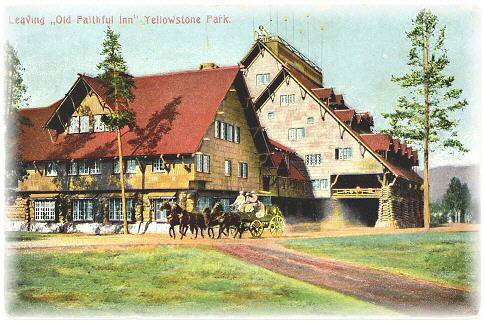
You are headed for Old Faithful, and the visitor's center, in the west central part of the park. In addition to the Old Faithful geyser, there's the Old Faithful Inn, which is, as I recall, the largest log structure in the U.S. and maybe the world. It was built back in 1904, and is still an operating hotel and restaurant. There's a vast freestanding stone fireplace in the middle of lobby, that extends up the 5th story ridgepole. Figure on lunch there.

About 25 or 30 miles into the park you'll catch a left on US20/89/287 at West Thumb (named for a thumb off Yellowstone Lake.) Follow US20 around to the turnoff to the Old Faithful area. You can't miss it; it's basically a freeway interchange. If you had any thoughts of escaping to the wild on a Yellowstone trip, forget 'em: Yellowstone hasn't been wild since the 1940's.

Get lunch, hang around to watch Old Faithful go off, and maybe take the trail walk around to look at some of the hot pools, then head on out north on the same highway. You are headed for the town of West Yellowstone, about 40 miles, where you'll overnight. (Some of these distances are pretty approximate. I'm taking them off old notes, an atlas, and a computer map.)

Along the way you'll find roadside thermal attractions like Geyser Basin and Paint Pots, and wildlife. Stop and have a look, you've got time, but DO NOT STOP FOR BEARS IF YOU CAN HELP IT. Although everybody else will do so, you don't have windows to roll up, and bears can get pushy. If you have food in your saddlebags or pockets, or are a woman having her period, they WILL get pushy. Since you are no longer at the top of the food chain under those circumstances, always give the bear what he wants; they don't understand "No" worth a damn. Stop and see anything but them.

At Madison, about 30 miles from Old Faithful, you'll come to a junction. Take the left fork, US20/287, headed to West Yellowstone. There's not too much by way of stops along that road, but it runs alongside a river, and it's mighty pretty country.

West Yellowstone is another western town with some shopping and eateries and quite a few motels, including the major chains. I'd Internet or phone ahead for reservations there, 'cause it can crowd up in August.

Click here to see various maps of Yellowstone, including mileages and attractions.

OK - you woke up in West Yellowstone, Montana this morning. The altitude is 6,600 feet, and you're in a place that frequently reports being the coldest in the lower 48 states. It's probably gonna be in the 40's at dawn, and only the 60's by midmorning. I've seen snow in August in some of the country you'll be riding in today. If you didn't bring a sweatshirt to go under your leathers, you shoulda bought one last night. Think about your ears, too.

Stoke up on breakfast while it warms up a little, then head back into the park the way you came.

When you get to the junction at Madison, turn left (north) on US89, headed for Norris. At Norris take a right on the road to Canyon; I don't have anything that shows the highway #; there may not even be one, but it'll be marked for Canyon.

At Canyon, you're up around 7,700 feet, and your bike will be running pretty damned rough if you didn't rejet. Also, whether you rejetted or not, you'll be noticeably down on power in Wyoming, so allow about 25% more room to pass than you are used to.

Once you are through at Canyon, head on up the road to Tower Falls. If you didn't have lunch yet, get it there, 'cause it's a long way to the next stop.

The reason I recommend this route instead of going north from Norris to Mammoth is this: you ought to leave the park by way of Beartooth Pass, it's too good a road to miss, but you really ought to see the Grand Canyon of the Yellowstone over at Canyon too - it's a "don't miss" also. In my mind, it's one of the best three or four things in the park. By taking this route, you get the Canyon and Beartooth, which I think is better than Mammoth and Beartooth.

If you want to add a day to the route, go up through Mammoth, then drop down to Canyon, passing the Beartooth intersection on the way, then come back up to it after you have seen the Canyon. You'll not want to go over the pass very late in the day though; afternoon in August often brings thunderstorms to it.

If you see thunderstorms in the high country ahead of you when you start up it, think about doing something else, like maybe going to back Mammoth and spending the night up in Gardiner, MT, then getting an early start back the next day. Those mountain storms will make a christian out of you if you're not one already, especially if you're on a bike, what with lightning strikes all around, and no place to hide. (See my report about an encounter with lightning here.) The riding is very, very treacherous in them, it'll be gusting wind, blowing rain, maybe hail and snow, and you'll be cold, so your skills will drop off. Don't challenge the weather up there - hard and fast rule - it can kill you quick.

Beartooth Pass Just beyond Tower Falls you'll catch a right, on highway 212, headed up Beartooth Pass. (There are some great pics on this link.) I hope for your sake the weather's good, 'cause that high country (the pass is 11,000 ft) is a weather-catcher. CAUTION: the vistas are pretty spectacular, and you'll be spending a lot of time looking away from the road. Don't forget that the first rule of riding is PAY ATTENTION! If you gotta look, I'd suggest stopping, because there are enough twists, curves, bends, switchbacks, and loops in the road that you might wind up wishing you had wings if you don't PAY ATTENTION!

After leaving the park, and before getting to Beartooth, you'll come to a junction with Wyoming Hwy 296, which heads off southeast to WY120, then down to Cody, WY. Stay on US212, though, and you'll go over the pass, coming down to Red Lodge, Montana.

At Red Lodge you can keep going north on US212; it takes you up to Billings and out onto the plains again. I-90 is up at Billings, the route back east, or particularly back to the Pacific Northwest if that's your destination.

Or, at Red Lodge you can also take a right on Montana 308, a pretty road over to Belfry, MT. At Belfry you can catch Montana 72 southbound, back to northern Wyoming, where you have several options. One of them is Cody, Wyoming. To me, it's one of the best towns in the west, and worth spending the night. It's named for William F. Cody, or Buffalo Bill. I think you'll like it, and if you are a Buffalo Bill fan, or a gun nut, drop by the Cody museum there.

In the morning, if you are going home to someplace back east, head out that way on US14; you're going back to Heaven, the Bighorn Mountains, to cross them at another spot than before. As you come down out of the Bighorns above Ranchester, WY you will have one of the most spectacular views in North America, looking east across the Great Plains, I swear you can see clear to Minneapolis.

If you are headed back to the west or southwest, and don't want to cross the Bighorns again, leave Cody on WY20. Stay on it all the way back to Thermopolis, then down through Riverton to Lander. Yup, you're gonna cover some ground you've already seen, from Thermopolis to Riverton, but there's no way out of it. At Lander, catch WY28 and head southwest till you come to WY372, where you'll turn left, south, to get to I-80 somewhere west of Green River, WY. That country is what I call the Big Empty. The time God spent making the Bighorns he got when he didn't spend much attention on that part of Wyoming, but there it is. Get gas any time you see a station and you are below a half tank - there's not much out there. The map is marked with the route in pale brown.

If you take US14 east out of Cody though you'll be blessed with more hours of beautiful riding, but when you get to Ranchester, back on I-25, the best of the ride is over. Here, you can make a choice. If you have no time, or don't care about Custer and his last stand, head back south on I-25, using a route of your choice to get back to Sturgis, or home.

The Sioux, who want to have the scene renamed to reflect Indian victory, have a good point when they say the the battlefield is the only one in the country named after the loser.
I say: do it.

If you have little time though, you can head north about 70 miles to the Custer Battlefield. There, you can stand on a hillside where Custer himself died, and see what an idiot he was. There are small clusters of gravestones, each placed where a man died, pitiful little groups that show Custer never managed to put together a defense in depth. He was defeated in detail, his men picked off as they retreated up a hillside. Major Reno, with the other part of Custer's command a few miles down the Little Big Horn, kept his personnel together. Although he took heavy casualties, they survived. A party found the mutilated remains of Custer's command a few days later, and the death spots were marked at that time.

From there, if you are headed back east, you can catch US212 back to Spearfish, and head on home. It runs through more Injun Country, and you can really get an idea of the isolated vastness that once was the American west, and see why Montana is "Big Sky" country. "The cowards never started, and the weak never made it" is a quote about the settling of the west from a source I don't remember. It explains why westerners were a breed apart in the U.S. until recently, the descendants of those early settlers. They were indeed a different breed, and we'll not see their like again until we colonize space, if we ever do.

TIP:Wear a long-sleeved shirt. Yeah, sleeveless T's are cool-looking, and get you a good tan, but they also get you sunburned and dehydrated. The long sleeves will actually keep you cooler over the long run. Just look around at Sturgis and you'll see who the fools have been. Heat will flat do you in without letting you know ahead of time - it's a real sneaky enemy, but you probably know that. What might surprise you if you're from back east is how the lack of humidity keeps it from feeling so hot, and I guarantee, you'll most likely see 100 degrees more than one day.

If you don't want to go all the way back to Spearfish, and fall into a return route home from there the same as you came, here's an excellent shortcut that changes the possibility.

On US212, about halfway from GarryOwen, near the Custer Battlefield, to Belle Fourche, you'll see the little town of Broadus. When you get there, turn south on Wyoming 59, headed down to Gillette, then all the way down to Douglas, WY. I've marked the route on the map , in pale blue. There, you'll get on I-25. You can either go on all the way to Cheyenne, and pick up I-80 east, or do what I'd do instead - stay off the superslab.

I believe that Interstates are a fast way to get somewhere in a hurry, but a terrible place to be. So, whenever I can, I always travel the old primary

Did you know that Garry Owen, after which the town is named, is an Irish song, the song of the U.S. Horse Cavalry? It was adopted by the cavalary because so many Irishmen, who have ever been wandering warriors, came to this country in the 1840's to escape the Irish potato famine. They joined the Army by the thousands, and many wound up in the Cavalry. Allegedly, Custer's men were riding to the sound of it when the Sioux engaged them. You may have heard it you've ever seen the old John Wayne movie She Wore A Yellow Ribbon.
US highways, and leave the superslab to the trucks and cops. The old primaries are nearly always good roads out west, very lightly patrolled by the speed tax collectors, don't have much traffic (most places), often take a more direct route than the I'state, and are waaaay more interesting. I usually cruise them at 70 to 75 without any trouble.

Scott's BluffGo about 50 miles down I-25 road from Douglas, and get on US26 eastbound at a junction out in the middle of nowhere. US26 roughly follows the old Oregon Trail, and there will be spots (one is near the junction with I-25) where you can still see the old wagon ruts. Just over the Nebraska line is the town of Scottsbluff, where you will see a huge, fortress-like cliff, Scott's Bluff, reaching for the sky. It was a major marker to the pioneers on the Oregon Trail. The Pony Express also came through here.

I won't try to tell you where to stop for the night, just do it wherever it feels like time, but don't expect to find lodging (or gas either)anywhere between Broadus and Douglas EXCEPT in Gillette. You might get lucky somewhere on the gas, but don't count on it. Leave Broadus and Gillette with full tanks.

Anywhere along this stretch to Scottsbluff you'll be ok to swap your jets back if you changed them before. You're still up above 5,000 feet, but you'll be dropping steadily from Scottsbluff on.

To head back to the southwest from Ranchester, I think your best route is down to Casper on I-25, then pick up WY220 to US287, then drop down to Rawlins on I-80. It's marked in pale green on the map. You can then pick up I-80 over to the Salt Lake City area, or if you are still in the mood for some beautiful mountain riding, go west out of Rawlins on I-80 till you can head south on WY789. That'll lead you down throuch Craig and Meeker, CO, to I-70 about 50 miles east of Grand Junction. It's an excellent road, but by far not as fast as I-80 to Ogden, UT.

OK - I gotcha headed back home now, so I'm gonna pass along a couple tips. You may know 'em, but, maybe not, so. . .

TIP: Carry and drink water, lots of it, and carry a little more than you'll think you'll drink. Make a spot for it where you can reach it as you ride. One of my saddlebags has a carrier built into the front for a full quart bottle that I drink from between gas stops, and I carry another small bottle in my luggage in case I break down halfway between Busted Flush, Montana and Moose Nuts, North Dakota and have to wait for help.

TIP: Don't look in your gas tank with a match!

TIP: Don't ride the old highways after dark at more than 50mph, your headlight just won't show you what's out there. I was ignoring my own advice one night down in eastern New Mexico back in 1991. I was cruising along US287 north of Roswell about 70 when ZIP, ZIP, ZIP, along each side of me, REAL CLOSE, were some antelope standing in the road, a whole damned herd. It was only by the grace of God I didn't T-bone one in the dark.

Click here
here to return to the top.
Or here to go to the Sturgis day ride. Or here for the wildwestcycle.com HOME page
if you came from outside the Wild West Cycle site.
Or here if you came here
from within wildwestcycle.com.