North on US89 to
Jct US89/SR12
- about 25 miles;
East, then north on SR12 to
Torrey, UT
- about 130 miles.
Click here for narrative
|
|
Leave Cedar City, UT via SR14. Ride east to junction with US89 - about 50 miles
North on US89 to
Jct US89/SR12 East, then north on SR12 to
Torrey, UT |
|
Click map or here for larger view.
Click here for narrative |
|
Cedar City to Torrey, UT
When I get off a motorcycle, if you ask me what's the best ride I ever had, I'll probably tell you it's the one I just finished.
But if you catch me in front of a campfire somewhere, with a drink and a cigar in hand, I'll most likely think back and come up with this one. Early June, 1997. It's late afternoon leaving Cedar City, Utah on State Route 14, and as I climb up into the high country the bluffs ahead are lit in a hundred shades of red and yellow and gold by the setting sun. About a two-thirds of the way to the crest there's a pullout with a view to the south. I think you can see all the way to Phoenix from there, and the country is so broken and carved by the streams that feed the Colorado River and Lake Powell to the south, that it looks like a jigsaw puzzle put together by a three-year old. From there you'll climb up over a 10,000 ft pass, then drop back down to about 8,000 feet while the highway runs on across the range of mountains, through the Dixie National Forest. The scenery is sub-alpine, beautiful meadows and icy ponds backed by deep forest alongside the gently twisting road. Late in the afternoon it's chilly at that altitude. About halfway across the top is a Duck Lake Village, a summer recreation center on small lake, with cabins, motels, a couple restaurants, and gas. The road drops back down to US89 on the east side of the mountains. There's gas and grub there, and a few miles north of the junction there's a KOA. Like all of them, it's a little too close to the highway, and loud due to the truck traffic on 89, and too expensive, but when it's growing dark the place is convenient.
A short ride in the morning brings me to the beginning of the best road in the country, at least on that morning. The day was warm, and the sky brilliant blue with a few puffy clouds.
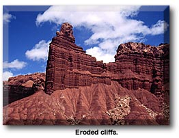
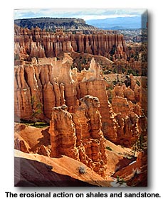
There's not a bad inch in all those miles. The pavement is good, although there are no shoulders in many places, and the traffic is light. There are no big trucks to be seen after you leave US89. It runs through scenic canyons (the entrance to Bryce Canyon National Park is just after the turnoff, and the entrance to Capitol Reef NP is at the other end) and along high ridges and mountainsides. One ridge is so narrow it almost qualifies as a hogback, with thousand-foot dropoffs on either side. A sign in one mountainside rest area says you can see an area as large as the state of Connecticut from there. I believe it. The road climbs high, I seem to recall it may go up as high as 9,000 feet in a couple spots, before it descends from the high country back down to canyon country at Torrey. Each descending curve brings forth a scream of joy: "Yeessss . . . I'm alive!!!"
Torrey is little more than a village serving the tourists in this scenic area. The entrance to
The town has several motels and restaurants as well as the usual collection of "stop & robs". You can't go wrong, scenically speaking, by turning either direction on Utah SR24 when you get there, but the best road in America is behind you. The section from the US89 junction to Torrey is about 130 miles; it may be a bit further, but not much. There is gas at at least two spots along the way, Escalante, and Boulder. Escalante is enough of a town that it has a selection of restaurants and motels as well. Allow at least three hours for the trip once you leave Bryce Canyon; you won't want to hurry it much. That'll give you time to pull over and look at stuff, and take lots of pictures if you carry a camera. Unfortunately, I didn't on that trip. |
|
|
 Utah SR12 runs about 130 miles to the northeast, from its junction with US89 near Panguitch, Utah up to its junction with SR24 at Torrey.